Local News
WEATHER STATUS BRIEFING: Noon 05252011
May 25th 2011 by Staff Writer
A STORM SHELTER HAVE BEEN OPENED IN THE FOLLOWING AREAS:
1. DEXTER AT THE FIRST BAPTIST
2. BLOOMFIELD CITY HALL
3. ADVANCE 1ST BAPTIST CHURCH
4. PUXICO LIFE CHAPEL ASSEMBLY
5. BERNIE COMMUNITY CENTER
6. DUDLEY—RICHLAND GRAIN
KDEX IS UPDATING THE PUBLIC OF THE SITUATION.
----------------------------------------------------------------------
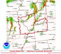
A major severe weather outbreak is expected across the Quad State region today and this evening. Storms are expected to quickly develop into supercells over southeast Missouri and southwest Illinois late this morning or early this afternoon. These storms will move northeast across the area at 35 to 45 MPH.
More development will be possible farther east across the region later this afternoon. Any storm will be capable of producing strong long track tornadoes, very large hail 2" or greater in diameter, and damaging straight-line winds. Everyone is encouraged to keep abreast of the weather today and know where to take safe shelter no matter where they are today.
A final broken line of severe storms along a dry line will enter southeast Missouri around 5 PM. This line of storms will move east across the area through the evening. All severe weather should be east of the area by Midnight.
Last Updated on May 25th 2011 by Staff Writer
https://showmetimes.com/Blogpost/uiq2/WEATHER-STATUS-BRIEFING--Noon-05252011

